From the syllabus:
Describe and evaluate one of the following two globalization indices: the AT Kearney index or the KOF index, as a measure of global interaction. Describe how the globalization index may be represented spatially.
Describe and evaluate one of the following two globalization indices: the AT Kearney index or the KOF index, as a measure of global interaction. Describe how the globalization index may be represented spatially.
What is KOF?
KOF is a Swiss company that produces the KOF Index of Globalization. It measures the level of global interaction within each country, has been doing so annually since 2002. It includes three areas of study:
It assesses these aspects in 207 countries and territories.
What is the scale?
KOF gives countries a globalization level on a scale of 1 to 100. The closer to 100, the more globalized the country. You can find the 2013 results at their website and more detail about it on the Wikipedia page. In 2013, Belgium scored the highest with 92.30 on the index.Though this page deals mainly with information from 2013, further details including the most recent rankings can be found at http://globalization.kof.ethz.ch/
This includes the press release which summarises the main changes. Ahead of your final exams, you should read the press release to update your notes with the most recent information.
Evaluating KOF
There are several positive and negative points about KOF.
Positive points include:
However, there are plenty of negative points too:
Remember that sometimes the same point can be both positive and negative. For example, here is a detailed summary of the benefits and problems of one evaluation point:
Establishes the level of globalisation for countries, not within countries.
This is a positive aspect, because it allows areas to be easily separated. Governments are usually significant contributors to the level of globalisation in a country because they control the borders over which economic and social indicators may flow. Therefore it is sensible to look at the nation state as a single unit. It also allows for easy comparison. However, it may be also be a negative point. Large countries such as China, India and Brazil have huge internal variations. This is particularly the case in low and middle income countries where there may be a highly globalised core surrounded by an almost completely non-globalised periphery, such as Kenya. Also, this might lead to the artificially high rank of a small or rich country due to economic strength per capita, as this is an average figure and may disguise huge wealth that is held by a very limited number of individuals within the country.
The spatial representation of KOF
The following graphic is taken from the Wikipedia page and is reproduced under the Creative Commons Licence. It shows the 2013 rankings, though the link may be updated at any time, so keep checking back.
KOF is a Swiss company that produces the KOF Index of Globalization. It measures the level of global interaction within each country, has been doing so annually since 2002. It includes three areas of study:
- social
- economic
- political
It assesses these aspects in 207 countries and territories.
What is the scale?
KOF gives countries a globalization level on a scale of 1 to 100. The closer to 100, the more globalized the country. You can find the 2013 results at their website and more detail about it on the Wikipedia page. In 2013, Belgium scored the highest with 92.30 on the index.Though this page deals mainly with information from 2013, further details including the most recent rankings can be found at http://globalization.kof.ethz.ch/
This includes the press release which summarises the main changes. Ahead of your final exams, you should read the press release to update your notes with the most recent information.
Evaluating KOF
There are several positive and negative points about KOF.
Positive points include:
- Uses a scale of 1 to 100, with 100 meaning a higher level of globalization, so it's simple to use
- The impact of extreme data points is reduced due to the weighting of individual components, so it gives a realistic number that suggests reliability
- Can be split into economic, social and political globalization levels, so it is possible to isolate which factors give a country a high (or low) score
- Economic globalization is divided into actual flows, and restrictions, so it isn't based simply on having a high GDP
- Economic globalisation is allocated 37% of the overall scale (note this figure changes each year), which is useful because the economy influences almost all other aspects of globalization
- Data is collected from a variety of sources, which increases reliability
- Political globalization measures membership of international organisations, embassies, participation in UN missions and international treaties, so it gives a clear indication of how open a country is to foreigners
However, there are plenty of negative points too:
- Social globalization includes information on tourism, telecoms, letters, number of McDonald’s restaurants per capita, number of IKEA stores per capita, and trade in books as a % of GDP. Some countries that don't have McDonald's or IKEA may have other foreign brands, such as Burger King, in their place.
- The trade in books is also unreliable as a country might have a low literacy rate, or a lack of disposable income, but still listen to foreign music or watch foreign films
- Small countries with successful economics feature prominently in the rankings, which suggests that internal disparities artificially reduce the level of globalization. A country such as China is significantly globalized in some areas such as Shanghai or Beijing, and yet appears relatively low in the rankings (44th place in 2013, with 85.85).
- As data is collected from a variety of sources, it is aggregated - which means that it has been manipulated differently depending on the country. This leads to a potential for discrepancies in the way countries are treated.
Remember that sometimes the same point can be both positive and negative. For example, here is a detailed summary of the benefits and problems of one evaluation point:
Establishes the level of globalisation for countries, not within countries.
This is a positive aspect, because it allows areas to be easily separated. Governments are usually significant contributors to the level of globalisation in a country because they control the borders over which economic and social indicators may flow. Therefore it is sensible to look at the nation state as a single unit. It also allows for easy comparison. However, it may be also be a negative point. Large countries such as China, India and Brazil have huge internal variations. This is particularly the case in low and middle income countries where there may be a highly globalised core surrounded by an almost completely non-globalised periphery, such as Kenya. Also, this might lead to the artificially high rank of a small or rich country due to economic strength per capita, as this is an average figure and may disguise huge wealth that is held by a very limited number of individuals within the country.
The spatial representation of KOF
The following graphic is taken from the Wikipedia page and is reproduced under the Creative Commons Licence. It shows the 2013 rankings, though the link may be updated at any time, so keep checking back.
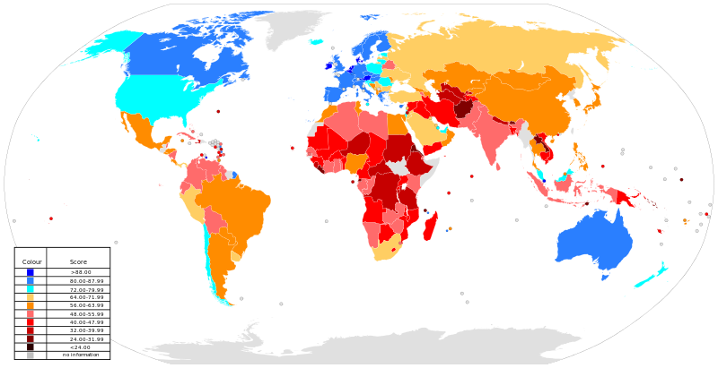
The map is a choropleth map, meaning it uses colours or shading to represent data. From the map it is clear to see that the most globalized countries are considered to be in western Europe and North America. It is notable that these areas correlate to high levels of GDP per capita, suggesting that globalization is strongly tied to the economy. Choropleth maps are useful to use because they provide an easy to understand graphic. However, they do not (like the index itself) show the varying levels of globalization within a country - for example, it is unlikely that a large area of desert in Western Australia could be considered as globalized as the south east of the country!
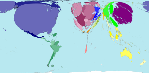
Other methods of displaying globalization spatially can be seen on this Slideshare presentation. However, note that most of them are choropleth maps with the exception of graphics such as the one below from the World Mapper website (territory size shows the proportion of all McDonalds restaurants that were open in 2004, that were found there). This is an interesting method, but hard to compare between countries with lower levels of globalization.
Other methods of displaying globalization spatially can be seen on this Slideshare presentation. However, note that most of them are choropleth maps with the exception of graphics such as the one below from the World Mapper website (territory size shows the proportion of all McDonalds restaurants that were open in 2004, that were found there). This is an interesting method, but hard to compare between countries with lower levels of globalization.