the syllabus says |
| ||
Characteristics of hazards
· Explain the characteristics and spatial distribution of the following hazards: (a) Either earthquakes or volcanoes (b) Hurricanes (tropical cyclones, typhoons) (c) Droughts (d) Any one recent human-induced (technological) hazard (explosion or escape of hazardous material)
· Distinguish between the chosen hazards in terms of their spatial extent, predictability, frequency, magnitude, duration, speed of onset and effects.
Defining 'hazard'
The IB Geography Subject Guide (2011) defines 'hazard' as: "A threat (whether natural or human) that has the potential to cause loss of life, injury, property damage, socio-economic disruption or environmental degradation".
Therefore, a hazard is any threat to humans or the environment. Hazards are not the same as disasters. More detail about the difference between hazards and disasters will be given in the disasters section of the site.
The four hazards that will be outlined on this page are:
Therefore, a hazard is any threat to humans or the environment. Hazards are not the same as disasters. More detail about the difference between hazards and disasters will be given in the disasters section of the site.
The four hazards that will be outlined on this page are:
- Earthquakes (an example of a tectonic hazard - which in themselves can cause further hazards such as tsunami)
- Typhoons (which is the south east Asian name for tropical cyclones, and are the same weather feature as hurricanes)
- Drought (a meteorological hazard)
- Nuclear accidents (a human-induced hazard; note that this will relate to nuclear power not nuclear weapons)
Defining Characteristics
Characteristics is a broad term that means "features of". The IB Geography syllabus requires the study of the characteristics of four hazards under the following headings:
- Physical characteristics
- Spatial distribution globally
- Spatial extent of hazard event
- Predictability
- Frequency
- Magnitude
- Duration
- Speed of onset
- Effects
- Physical characteristics
Definition: Physical characteristics refers to a descriptive account of what the hazard involves. Remember that this is a description of the hazard, not the hazard event - so earthquakes refers to the shaking of the ground, but the extent to which the ground shakes, and the reasons for it, depends on the specific hazard event.
Earthquakes: Physical characteristics
The video below describes several features of the shaking of the Earth's crust that is an earthquake. Note especially the meanings of the following terms: focus; seismic; P, S, Love and Rayleigh waves; and the conditions under which an earthquake is more severe.
The video below describes several features of the shaking of the Earth's crust that is an earthquake. Note especially the meanings of the following terms: focus; seismic; P, S, Love and Rayleigh waves; and the conditions under which an earthquake is more severe.
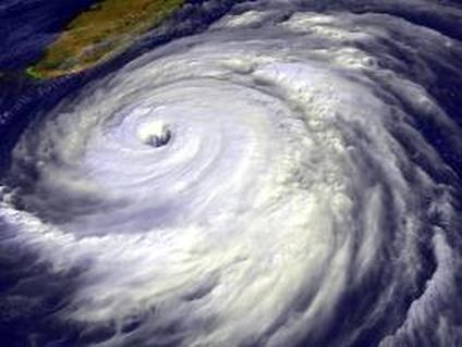
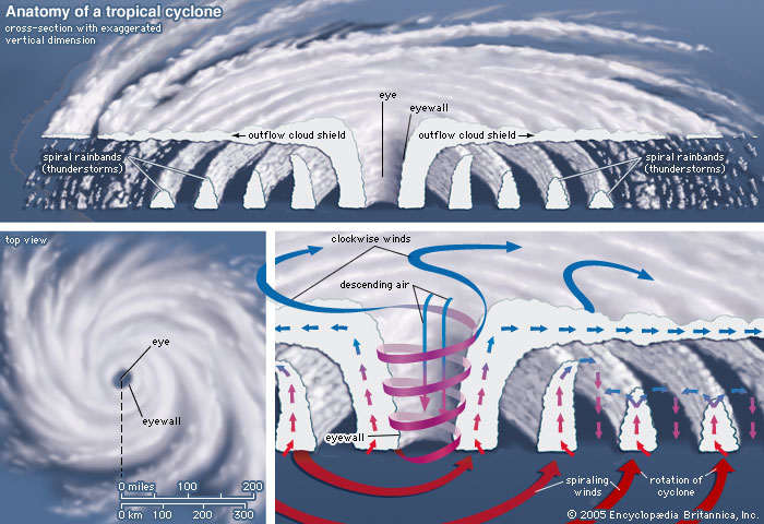
Tropical cyclones: Physical characteristics
There are some key features of tropical cyclones regardless of where they are found in the world:
- wind speeds of over 118kmph
- a central 'eye' with low wind speeds, relatively cloudless
- rainbands radiating out from the centre (see diagram below)
- clockwise spinning in the southern hemisphere, anti-clockwise spinning in the northern hemisphere
- formed in equatorial regions with high ocean temperatures (26°C)
|
"Hurricanes 101" describes the general features of tropical cyclones, with a focus on the USA.
|
"How a hurricane is born" is a video that explains how tropical cyclones are formed.
|
Source: http://pmm.nasa.gov/education/articles/what-hurricane-typhoon-or-tropical-cyclone
|
Source: http://global.britannica.com/EBchecked/topic/606551/tropical-cyclone
|
Droughts: Physical characteristics
It's important not to confuse drought with aridity, which is a permanant state of dryness. Depending on the context, drought can have different meanings. This is because some areas do not rely on rainfall for their water supply, but snowmelt, groundwater or floods. Therefore, drought can be split into the following categories. The information is taken from livescience.com.
Meteorological drought is specific to different regions. For example, 20 inches (51 centimeters) of rainfall in a year is normal in West Texas, but the same amount would be less than half the yearly average in Virginia.
Agricultural drought accounts for the water needs of crops during different growing stages. For instance, not enough moisture at planting may hinder germination, leading to low plant populations and a reduction in yield.
Hydrological drought refers to persistently low water volumes in streams, rivers and reservoirs. Human activities, such as drawdown of reservoirs, can worsen hydrological droughts. Hydrological drought is often linked with meteorological droughts.
Socioeconomic drought occurs when the demand for water exceeds the supply. Examples of this kind of drought include too much irrigation or when low river flow forces hydroelectric power plant operators to reduce energy production.
Nuclear accidents
The physical characteristics of nuclear accidents can be categorised by the nature of the escape of radiation. This is always through the release of radioactive materials, not 'radiation' itself. These can be liquid or atmospheric gas. In many cases, the release of the radioactive material is a deliberate choice as it is necessary to prevent the overheating of the nuclear reactor core which would then potentially cause an explosion, releasing a much greater amount of nuclear material into the atmosphere.
The physical characteristics of nuclear accidents can be categorised by the nature of the escape of radiation. This is always through the release of radioactive materials, not 'radiation' itself. These can be liquid or atmospheric gas. In many cases, the release of the radioactive material is a deliberate choice as it is necessary to prevent the overheating of the nuclear reactor core which would then potentially cause an explosion, releasing a much greater amount of nuclear material into the atmosphere.
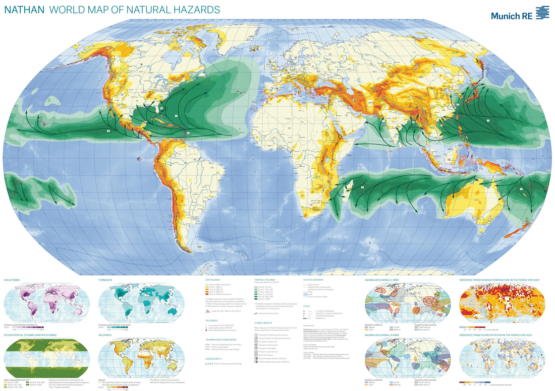
spatial distribution
Munich Re produce the NATHAN world map of natural hazards. The full PDF including smaller maps can be seen here. The map shows the worldwide distribution of earthquakes (yellow and orange) and tropical cyclones (green).
|
Nuclear Power
The map to the right shows the available data for the existing nuclear power stations around the world. It's important to note that since nuclear power is always produced under highly technical conditions, there is no greater likelihood of a plant failing in one location than another. Drought
For up to date drought information, go to the US Global Drought Information System. Be careful with assuming this data tells you about all drought - much drought is highly seasonal, and will vary during the year. The map below shows the extent of drought according to the Palmer Drought Severity Index. |
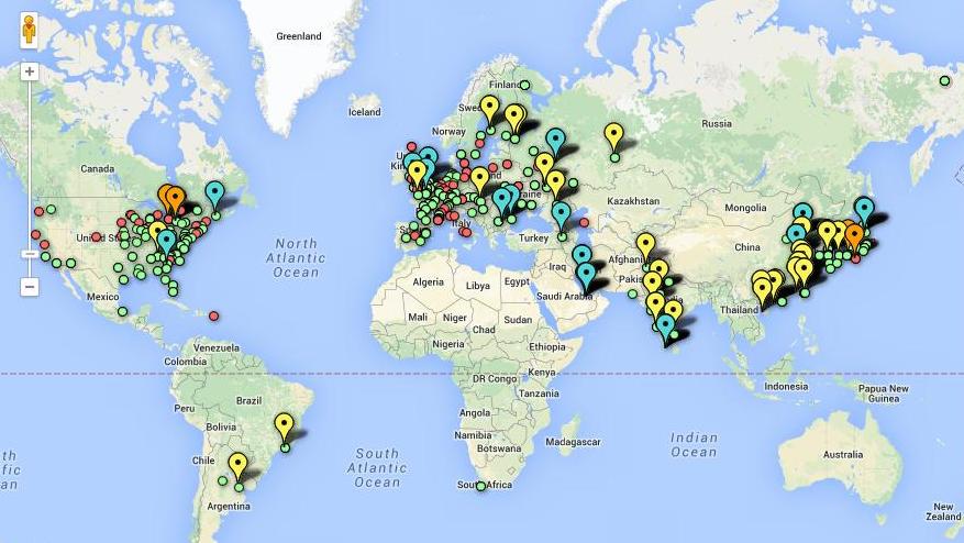
Map source: http://www.theguardian.com/environment/interactive/2012/mar/08/nuclear-power-plants-world-map
|
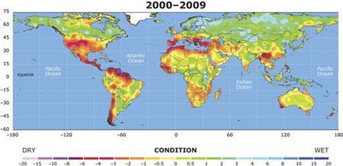
Source: http://www.reuters.com/article/2010/10/19/us-climate-drought-idUSTRE69I3MD20101019
spatial extent of hazard event
'Hazard event' refers to the occurrence of a hazard in a specific time and place regardless of the impact on humans. More discussion on the difference between 'hazard event' and 'disaster' will be available on other pages.
The spatial extent of hazard events depends on many things, including the magnitude of the event and the duration in time. However, as a rough indication:
Earthquakes: spatial extent is usually local, i.e. within a few kilometres of the epicentre. Seismic waves can sometimes be felt hundreds of kilometres away, but this depends on the local geography. For example, the L'Aquila earthquake in Italy in 2008 was felt in Rome (by the author!), over 97km away. However, the seismic shocks in Rome were very mild and were felt because Rome sits on a geologically unified mound of tufa (a type of limestone) which transmitted the seismic wave to the surface. A point of interest is that the Richter Scale is designed for use within 600km of the focus of the earthquake, which gives an indication of the maximum spatial extent of earthquakes generally.
Tropical cyclones: a cyclone is defined as a tropical low pressure weather system with a maximum sustained surface wind of 119kmph (note some sources round down to 118kmph). These are generally very large in spatial extent, with a typical tropical cyclone creating these wind speeds over a distance of around 160km in diameter. If the gale force winds that are part of the cyclone but not inside the peak wind area are included, the typical spatial extent rises to around 500km in diameter. However, these vary wildly depending on the severity and location of each individual storm.
|
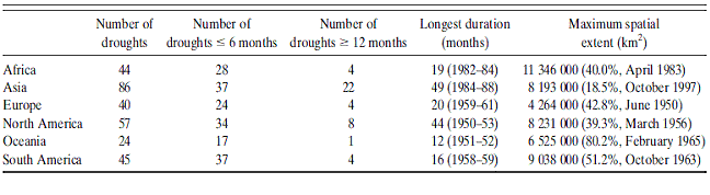
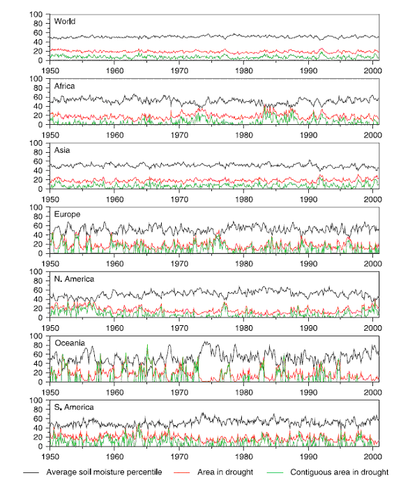
Drought: This depends significantly on the type of drought. Agricultural drought may affect one river basin. However, hydrological drought is weather dependent and so frequently an entire continent can be affected. To date, the largest single drought event was that of the 1980s African drought, covering 11 million square kilometres in April 1983. The image below shows the area in drought (red line, in % of continent in drought) in 2010 for each continent.
|
Source for table above and graphs below: http://www.worldclimatereport.com/index.php/2010/02/24/update-on-global-drought-patterns-ipcc-take-note/
Note for graph: Monthly time series of area-averaged soil moisture percentile, percentage area in drought, and percentage contiguous area in drought (from Sheffield et al., 2009) |
Nuclear accidents: The spatial extent of nuclear accidents is highly localised except where radioactive material is released into the atmosphere where it is easily spread by wind. This occurred across Europe following the 1986 Chernobyl disaster. The map below (left) shows the extent of deposition of radioactive material. The map below (right) shows similar information for the Fukushima disaster of 2011. Incidentally, radioactive material dispensed into the ocean has a much lower 'spread' due to the dilution in water, making it almost untraceable over larger distances.
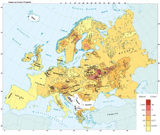
Source: http://www.greenfacts.org/en/chernobyl/figtableboxes/figure01.htm
|
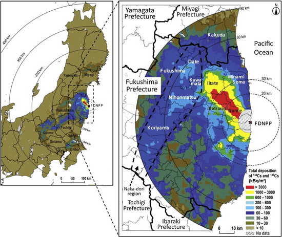
Source: http://fukushimainform.ca/2014/11/21/comparing-the-environmental-impacts-of-the-chernobyl-and-fukushima-disasters/
|
predictability
|
In this instance, the hazards can be grouped together. All these hazards are generally predicted by looking at past events and looking for patterns.
Earthquakes and nuclear accidents: These are highly unpredictable. Earthquakes are the result of a physical process that is not understood, although there have been some breakthroughs over the past decade. Prediction can only occur in general areas; more detail is given in the "Hazard event prediction" page. Nuclear events are not generally predicted, because if they were predicted, humans would have affected the process e.g. by making technical alterations or closing the nuclear plant down. |
|
Tropical cyclones and drought: Meteorological hazards like these can be predicted but without certainty. The complexity of global atmospheric circulation (studied more in Core 3) means that it is impossible to include enough factors in the computer models used to predict the development of tropical cyclones and/or rainfall.
frequency, duration and speed of onset
These are all temporal aspects of the hazard, so are dealt with together here. Frequency refers to the number of hazard events in a given period of time. Duration is how long the hazard event lasts. Speed of onset is how quickly the peak of the hazard event occurs, with the starting time at the first point of the process towards it becoming a hazard.
|
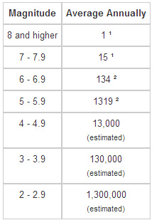
Earthquakes
The United States Geological Service estimates that there are millions of earthquakes every year, but that the vast majority go undetected. The table to the right shows the USGS estimates for annual earthquakes based on observations from 1990. Note: the source for this data has not been updated since 2012. Earthquakes generally last for only a few seconds, but this is for each individual seismic shock. The foreshocks and aftershocks may last for days or weeks. It is highly irregular. The speed of onset of an earthquake is almost instant. However, Primary (P) waves are released and move more quickly through the crust than Secondary (S) waves which do more damage. However, the difference is only seconds and so too fast to warn people effectively. |
|
Tropical cyclones
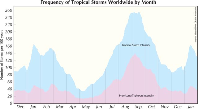
The information in the graphics below shows:
- tropical storms occur more frequently in the periods August to October, with a secondary peak between January and March
- globally, there has been an increase in the major storms but not necessarily a corresponding increase in the total number of storms
- strong storms occur more frequently in south east Asia than anywhere else
Tropical cyclones generally last for a few days before their wind speeds reduce to the level of a tropical storm. They significantly decrease in strength once they are over land, as the source of energy (warm sea waters) is gone.
Tropical cyclones move slowly over the ocean, so the speed of onset is gradual with communities having several days of warning that a storm may be approaching. However, their track is unpredictable so the speed of onset can in fact be very fast for an unsuspecting community.
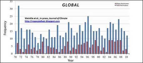
Source: http://c3headlines.typepad.com/.a/6a010536b58035970c0168e7849000970c-pi
|
Source: http://earthscience.stackexchange.com/questions/811/why-is-the-atlantic-hurricane-season-defined-as-being-between-june-1-and-novembe
|
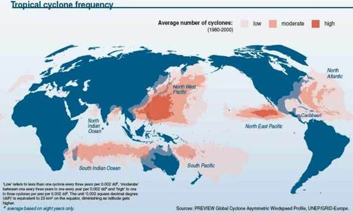
Source: http://www.grida.no/graphicslib/detail/tropical-cyclone-frequency_1487
Drought
See above for the graphs showing the area under drought. This shows clearly that drought is an ongoing occurrence and so frequency cannot be measured in the same way as for specific events that are shorter term. Rather, drought should be seen as a long term hazard. The speed of onset is very slow and can be measured in months, as drought is a hazard that goes through several stages before it is officially termed a 'drought'.
See above for the graphs showing the area under drought. This shows clearly that drought is an ongoing occurrence and so frequency cannot be measured in the same way as for specific events that are shorter term. Rather, drought should be seen as a long term hazard. The speed of onset is very slow and can be measured in months, as drought is a hazard that goes through several stages before it is officially termed a 'drought'.
Nuclear accidents
Though nuclear accidents get big headlines, in general the effects are short term. The impact of radioactive material from Fukushima had reduced to safe levels within one year, though it was still several times the background radiation level. Meanwhile, the Chernobyl area is still off-limits and will be for decades to come. In general, there will be only a very short warning period before a nuclear accident, but technological safeguards mean it is often several hours before the peak hazard event occurs. Even then, the safeguards must fail for the peak event to occur.
Though nuclear accidents get big headlines, in general the effects are short term. The impact of radioactive material from Fukushima had reduced to safe levels within one year, though it was still several times the background radiation level. Meanwhile, the Chernobyl area is still off-limits and will be for decades to come. In general, there will be only a very short warning period before a nuclear accident, but technological safeguards mean it is often several hours before the peak hazard event occurs. Even then, the safeguards must fail for the peak event to occur.
magnitude
Magnitude refers to the size of the hazard event. Each hazard has a scale (or sometimes several scales) which measure a certain aspect.
Earthquakes
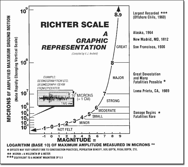
These are generally measured using the Richter Scale, which measures the amount of shaking of the crust at the epicentre. The Richter Scale is a base-10 logarithmic scale, so a force 6 earthquake is 10 times stronger than a force 5 earthquake, and 100 times stronger than a force 4 earthquake.
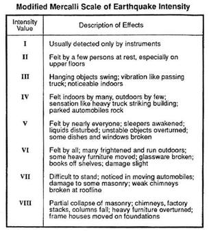
However, this doesn't measure the damage, so the Mercalli scale is sometimes used. The Mercalli scale exclusively measures the effects of earthquakes and is highly subjective.
These are generally measured using the Richter Scale, which measures the amount of shaking of the crust at the epicentre. The Richter Scale is a base-10 logarithmic scale, so a force 6 earthquake is 10 times stronger than a force 5 earthquake, and 100 times stronger than a force 4 earthquake.
However, this doesn't measure the damage, so the Mercalli scale is sometimes used. The Mercalli scale exclusively measures the effects of earthquakes and is highly subjective.
|
|
Tropical cyclones
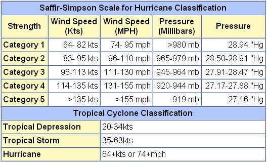
For hurricanes affecting the USA and neighbouring countries, the Saffir-Simpson Scale measures the sustained wind speed of the cyclone and rates it according to a 1 to 5 scale. Note that the entry point to the scale is 1, meaning the storm has already become a tropical cyclone.
In Hong Kong, the Hong Kong Observatory uses a descriptive scale in which wind speeds over a period of 10 minutes near the centre of the storm are used to classify the storm as a typhoon, super typhoon etc. The tropical cyclone level appears at 'typhoon'.
Source: http://www.westernpacificweather.com/scales/saffir-simpson-scale/
|
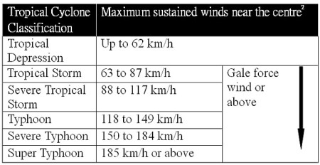
Source: http://www.hko.gov.hk/blog/en/archives/00000114.htm
|
Drought
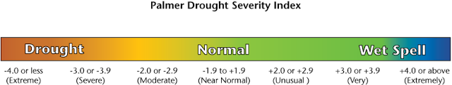
Droughts can be measured using the Palmer Drought Severity Index. The following information is taken from the US Drought Portal, an excellent resource about drought.
The Palmer Drought Severity Index (PDSI, weekly index from CPC shown), devised in 1965, was the first drought indicator to assess moisture status comprehensively. It uses temperature and precipitation data to calculate water supply and demand, incorporates soil moisture, and is considered most effective for unirrigated cropland. It primarily reflects long-term drought and has been used extensively to initiate drought relief. It is more complex than the SPI and the Drought Monitor.
Source: http://excelmathmike.blogspot.hk/2010_01_17_archive.html
Nuclear accidents
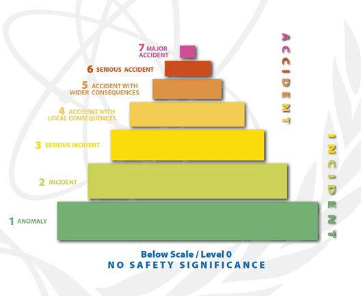
The International Atomic Energy Agency uses the International Nuclear and Radiological Event Scale (INES). It is designed in the same way as the Richter Scale for earthquakes. Three areas are used to decide what level an event falls on - off-site effects, on-site effects, and defence in depth degradation. Effectively, these mean things that happen in the event outside the power station, and things that happen in the event inside the power station. Defence in depth degradation refers to the number of the safety measures that fail. The criteria used are variable from event to event, and the actual level that is given to an event is often altered well after the event once new factors are considered.
The International Atomic Energy Agency uses the International Nuclear and Radiological Event Scale (INES). It is designed in the same way as the Richter Scale for earthquakes. Three areas are used to decide what level an event falls on - off-site effects, on-site effects, and defence in depth degradation. Effectively, these mean things that happen in the event outside the power station, and things that happen in the event inside the power station. Defence in depth degradation refers to the number of the safety measures that fail. The criteria used are variable from event to event, and the actual level that is given to an event is often altered well after the event once new factors are considered.
Source: http://www-ns.iaea.org/tech-areas/emergency/ines.asp
